(Front and associated trough sweep from east to west over Central US. Image source: NOAA)
An extreme US summer that has featured floods and heavy rains in the east and drought and devastating fires in the west boasts yet one more bizarre weather pattern: a backward moving storm system. Is this just one more sign of a ‘pole shift’ due to the existence of another planetary body in outerspace approaching the Earth? Is this weather modification? HAARP? It is said that the jetstream over America is so weak, the weather is moving backwards… Coincidentally, or not, HAARP seems to be heating up much of the same area.
As of last week, a strong frontal boundary had swept into the southeastern US bringing with it another dose of heavy rains and storms. Then the system stalled. Over Friday, Saturday and Sunday, the front and associated low pressure systems have backed up, moving from east to west, passing over the Appalachians, then the Tennessee River Valley, then the Mississippi, until today it reached a central region stretching from Texas all the way north to the Dakotas.
This retrograde weather is a very uncommon, but not unheard of, event. In the context of an already strange summer, it adds yet one more anomalous weather pattern to the list. In the AQUA/NASA image below, we can see the position of this retrograde frontal boundary and low pressure system as of yesterday. Note how the eastern front essentially collapsed as it pushed westward forming a bow from Texas to the Dakotas in the image at the top of this post.
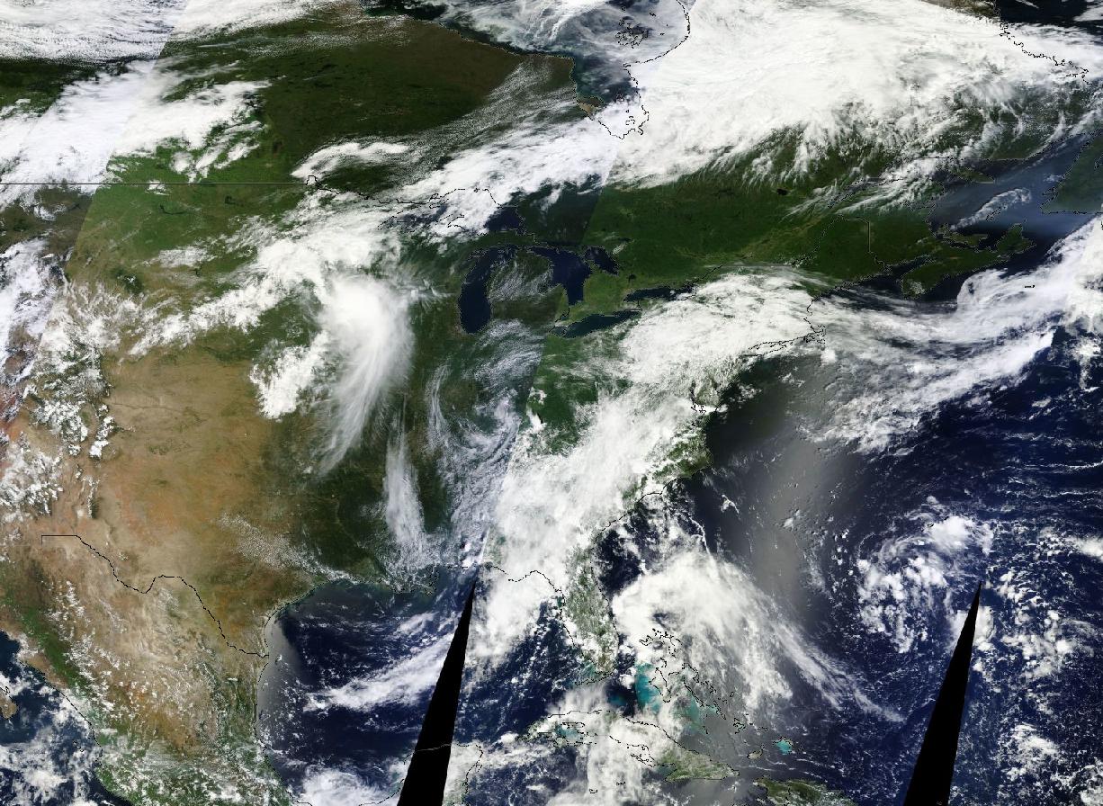
(Frontal System begins to move in reverse on Saturday, July 13. Image source: NASA)
The cause for this retrograde storm motion is an extraordinarily weak Jet Stream. Over the past two decades, the Northern Hemisphere Jet has continued to weaken as both sea ice and summer time snow cover rapidly eroded. This helped reduce the strong north-south temperature differentials that drove the Jet to move weather systems rapidly from west to east. Now, temperature differences between high and low lattitudes are greatly reduced and, as a result, the Jet proceeds more slowly.
One result is that weather tends to persist much, much longer over a given region. Droughts, heat, and dry weather persist in areas where the Jet is pushed into a south-north configuration. Rain, storms, and cooler weather persist in regions where the Jet is pushed into a north-south configuration.
In the case of this weekend, the Jet became so weak that prevailing local influences overcame a hemisphere wide system to drive weather patterns against its ebbing flow. In this case, though, the result may be a somewhat positive influx of rainfall to drought and fire stricken western regions. Let’s hope this doesn’t turn into too much of a good thing.
UDPATE:
The weather system I reported on earlier today is still moving in its retrograde fashion, east to west, across the United States. It now stretches almost to Utah and appears to be dumping rain in a bow shaped arc from Texas into New Mexico and then re-curving northward back through the Dakotas and all the way through to Quebec. A moist upper level flow issuing from the Atlantic Ocean is still pushing the arching front westward.
You can see the progress of this retrograde storm in the most recent satellite image here:
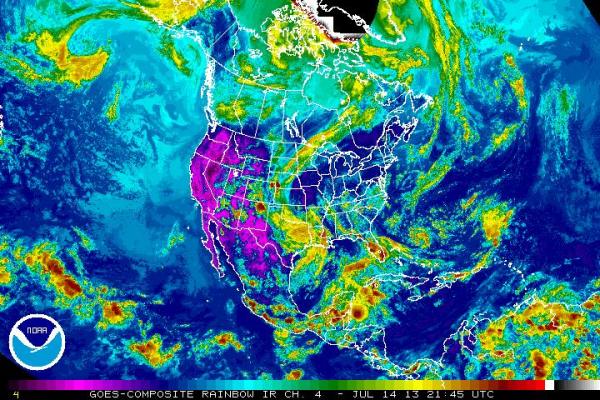
(Image source: NOAA)
This retrograde action has now spanned 2/3 of the Continental US and is still proceeding westward. May well be something for the record books…
Links:
http://robertscribbler.wordpress.com/

Greetings, Having followed this system and its “Path of Least Resistance”, captured in satellite imagery for the entire passage to the S.W., I know bring to question the storm forming in the Pacific at about 40 degrees Lat. Doppler imagery ranges in the same frequencies that “HAARP’ and similar systems are now registering activity; in the Seattle, WA. region and surrounds. Subsequently, the movement of this retrograde storm has been predictable, and I have been writing of it for 10 days since it became apparent that Weather Modification, for some purpose (?) was in play. At this time, Vance Air Force Base, OK., Poway, North of San Diego and El Paso,TX. are registering strong Modulated Pulsed Wave Forms in active function. This is my comment from Dane Wigington”s “GeoEngineering Watch.org” site early yesterday… ” Greetings, I have noticed the same system and been pulling satellite and doppler imagery as it both travels and is fed pulsed and continuous wave forms, in advance mostly of its movement. I understand that storms will move in this fashion in nature. The thing here is that of a pathways being cleared through the creation of “Voided Space”. This enables the movement toward the “Path of Least Resistance”. It has the secondary action of allowing the storm to intensify, pulling energy that becomes available from the cleared/ directed paths surrounding areas. The most recent and obvious activity has been just North of San Diego. There with no weather system in the area, ( Both the doppler and satellite imagery confirm…) constant and pulsed bursts of wave forms were managed for hours. This was in the a.m. hours and falls in the historic timeline of action creating extreme weather, approximately 72 hours later. I have been filing and writing articles with regard to these radar captures, and in so doing have noticed the reverse Event. While it may be of nature, it is dubious in the least. The dots seem to connect, timeline, pathway, storm intensification, and retrograde nature all point to the electromagnetic usage as part of an agenda. It is harder to capture the GeoEngineering aspect, its presence, an aspect that I believe from what has been archived is coupled in this agendas operation. The saturation of the mosaic layers, which in advance of the introduction of Energies, creates excitation and movement; this seems a given. Thank You for the article, glad someone else confirmed what appeared to be happening from my research… Be well… o… 17th July, 2013 7:50 a.m. EDT P.S. If I could I would post the South Central satellite gif of the same storm, it is in my files… (Just confirmed…)
This is a comment going to an article, it had some of the same data and far more sophisticated systems. As this comment could turn to data enough for an article, I will end here. It still bothers me the way the second storm is being brought into play… Survive-All… Otter Walks on Two Feet… 18th July, 2013 6:45 p.m. EDT
Bizarre is an accurate descripton of this weather. Local and national weather channels aren’t touching any of this pattern with an explanation…….just mumbo jumbo gibberish or to say it is “unusual”. Gee, ya think we don’t know that already? Now, what are the REAL reasons would be appreciated and I am sure it is sinister!