We Have Been Misled By An Erroneous Map Of The World For 500 Years.
This clip was featured in “The West Wing,” but map dishonesty is anything but fictional. Check out the video to get an accurate look at the size of Africa.
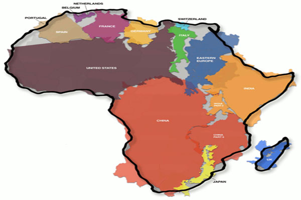
The map shows how Africa (30,3 million km²) is larger than the combination of China (9,6 million km²), the US (9,4 million km²), Western Europe (4,9 million km²), India (3,2 million km²) and Argentina (2,8 million km²), three Scandinavian countries and the British Isles (map gives no surface for these last two areas). Map Source
The Peters Projection World Map is one of the most stimulating, and controversial, images of the world. When this map was first introduced by historian and cartographer Dr. Arno Peters at a Press Conference in Germany in 1974 it generated a firestorm of debate. The first English-version of the map was published in 1983, and it continues to have passionate fans as well as staunch detractors.
The earth is round. The challenge of any world map is to represent a round earth on a flat surface. There are literally thousands of map projections. Each has certain strengths and corresponding weaknesses. Choosing among them is an exercise in values clarification: you have to decide what’s important to you. That is generally determined by the way you intend to use the map. The Peters Projection is an area accurate map.
Because the only totally correct representation of the earth is a globe, cartographers have to distort the sphere in order to print it on flat paper to produce world maps. In the process scale, distance, area, or a combination of these, are rendered imperfect.
Traditional world maps such as the Mercator often exaggerate the scale towards the poles, giving an erroneous picture of the relative sizes of different countries. For example, Mercator maps show Greenland to be roughly the same size as Africa, when, in reality, Africa is actually fourteen times larger. Africa also looks considerably smaller than Russia on a Mercator map, even though Africa is actually 33% larger. However, generations of navigators weren’t bothered much by Mercator’s misrepresentations, since they cared most about longitude and latitude, which the Mercator projection handles rather well.
In 1973, Arno Peters published the Peters Projection map. This map preserves equal area and retains a rectangular grid of latitude and longitude. Thus all countries are the correct size in relation to one another. On this projection it becomes much easier to understand the relationships between countries. However, a price is paid in the distortion of shape – countries are progressively squashed towards the poles and stretched across the equator. For those who grew up with the Mercator map, the Peters projection map appears to be stretched vertically, and Africa suddenly looks huge.
A variety of social and religious groups argue that since the Mercator map makes many countries appear smaller than they really are, people seeing them may infer that certain countries are innately more important than others. This rhetoric has often escalated to the point where the Mercator map is openly described as being “racist”. Many of these groups are working to address this perceived problem by lobbying schools around the world to adopt the Peters projection map in classrooms. This movement is not without controversy, however, since educators, well-aware of the Mercator map’s deficiencies, were already adopting maps based on other projections, some of which are even more accurate than Peters’s. Others argue that Peters wasn’t even the first person to devise such a projection, since James Gall came up with the same idea in 1855 (which is why some refer to it as the Gall-Peters projection).
In my experience anything that is a product or resident that comes from beyond the East coast or beyond the West coast and now the south is considered legally alien, inferior and needs to be eliminated unless we own it, gain pleasure and merchant-ability from it, is it copywrite or patented or most importantly can we tax it . Then it is more than welcome. As a secular society nothing will exist before us, unless we can exploit it and when we go we will make sure nothing exists.
We have a God given legal right to think what we want, do what we want and better yet we have the most powerful and adsurd private legal system in the world to enforce profit and policies based on our thinking with a private army that is protected by our laws to go anywhere it wants and do anything it wants..
Our laws provide that any serendipitous thinking that will make money or provide continuity for our way of life and for those who live well on making it so, even if those who exploit it the best actually do have residences in weird places like Caans, St Tropez or Zurich or even London or a tropical island they have earned from profit. We are the best thing ever since sliced bread and we get everything we need in a box all pretty and packaged so that we don’t have to worry about the little problems of the world.
Asking why not south on top instead of north , is like asking why we walk on our feet instead of our heads.
No one deliberately set out to marginalize anyone. The map is nothing more than a spatial perception. It wasn’t an imperialist plot. Speaking of agendas; the crazies now run the asylum.
Please close the door on your way out.
Excellent!!! I appreciate this as I appreciate all truth. Imperial thinking has reshaped reality ion their own thinking.
Why is North Up? Is there any reason that North cannot be down? Is God from up? Does God prefer North over South?
Supposed truth provided by agenda is very deceptive.