by Neil W. McCabe
(Human Events)
A former China-desk Army intelligence analyst and co-author of a new book about Chinese-American relations, told HUMAN EVENTS November 15 that the strange giant white lines drawn in western China’s Gobi Desert were most likely practice targets for Chinese space weapons.
“Usually when we think of space weaponry, we are talking about horizontal targeting by satellites firing on other satellites—to take your eyes out,” said William C. Triplett II, who with Brett M. Decker, wrote Bowing to Beijing: How Barack Obama is Hastening America’s Decline and Ushering A Century of Chinese Domination.
The former analyst said at first he was skeptical.
“I have been waiting to hear that the images were Photoshopped,” he said. After two days, he came to seriously consider what the lines were with other members of his community of China watchers. “It is all we are talking about.”
 There are three images in question. Two are white lines drawn on the desert floor without regard for the topography. One of the two has lines inside a rectangle and the other has lines loose without a box border. The third is a series of concentric circles.
The image without the box could be an airbase with runways on the left side, he said. It could not be a city or town because unlike the boxed image, the boulevards are not long enough and are not laid out in a practical way.
After ruling out the new cities, Triplett said there are three factors that lead him to think that are tied to the Chinese space weaponry program.
First, the images are close to the Chinese government’s military space headquarters, which has long-been centered in the western desert, he said.
Second, the Chinese are developing powerful space-based weapons that have the ability to fire on earth and they have always tested their weapon systems away from populations, both for safety and security reasons, he said.
 The third reason is that the lines are consistent with the practice of large modeling, he said.
“Modeling is very popular in Asia,” he said. “There is a famous photo of a Japanese mock-up of Pearl Harbor with men walking around it with rubber boots.”
The Chinese are famous for their three-dimensional models, too, he said. “In Wuhan, the Chinese built a life-size American aircraft carrier.”
The Chinese love using models and to see models from space, they have to be very large, he said.
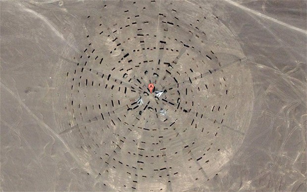
Of the three images found on Google maps, Triplett said the one with concentric circles with easily discernible trucks and aircraft was the easiest to identify. “It is an atomic bomb test site.”
It is not uncommon to leave equipment at test sites, he said. The American military did the same thing after its desert tests.
Triplett said early in his career in the late 1960s, he became familiar with test sites in China.
“I was the youngest guy in the office, so while everyone else was watching the Cultural Revolution, I was told to keep my eye on the Western desert,” he said. It was during this time, as an Army analyst on loan to another federal agency that Triplett was the first American to report that the Chinese had conducted the only known test of a missile with an armed nuclear warhead.
“Many people thought it was irresponsible, they never did it again,” he said. “Back in those days, we were mostly worried that the Chinese would get into Vietnam, like they did Korea.”
Images courtesy of Google Maps.

The square is a map of Washington dc